Who is ‘Edwards,’ anyway? 5 things to know about the Edwards Aquifer.
Published: Mon, 11/27/23
Who is ‘Edwards,’ anyway? 5 things to know about the Edwards Aquifer.
The aquifer is a key water source for San Antonio and the Hill Country. Here’s how it works and why it’s important.
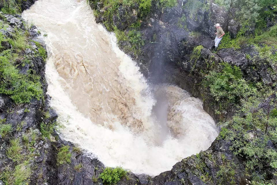
Chester, an employee of a private ranch two hours west of San Antonio, stands on the edge of a large sinkhole as about 500 cubic feet per second of water go down the hole into the Edwards Aquifer in this 2016 photo. The sinkhole is one of the largest single recharge features for the aquifer.
William Luther/San Antonio Express-News
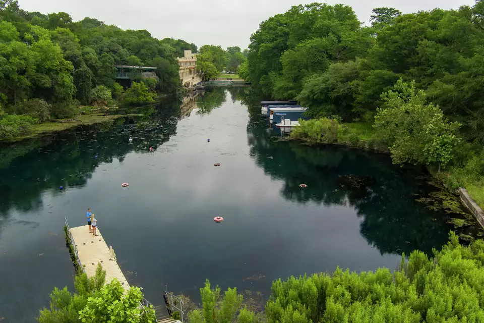
Spring Lake in San Marcos is formed by the San Marcos Springs, which rise from the Edwards Aquifer, the limestone cavern system that provides water for more than 2 million people.
William Luther/Staff
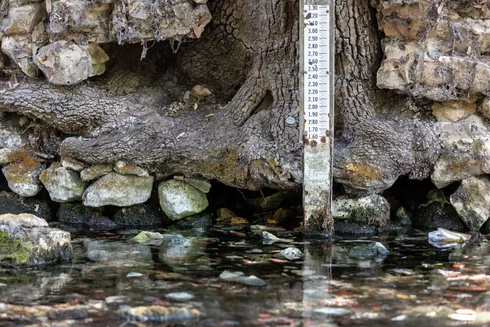
A water gauge sits in Landa Park in New Braunfels, just downstream from the largest of the major springs that make up Comal Springs. The Edwards Aquifer Authority tracks spring flows at Comal Springs and San Marcos Springs as two measures of the health of the aquifer.
William Luther/Staff photographer
San Antonio Express-News
By Liz Teitz, Staff writer
You’ve likely heard about the Edwards Aquifer, especially over the past few drought-stricken years.
The groundwater system provides water for more than 2 million people, and water levels in recent months have dictated watering restrictions, making them a tangible issue for many San Antonio-area residents.
The aquifer is a vital part of the region’s water supply and it’s the largest and most prolific groundwater source in the state, according to the University of Texas Bureau of Economic Geology. It’s also home to several endangered and threatened species.
Here’s what you need to know about the Edwards Aquifer:
What is it?
The Edwards Aquifer — formally, the Edwards Balcones Fault Zone Aquifer — is a limestone cavern system that holds and stores water underground. Water can be pumped from the aquifer or rise to the surface naturally through springs. Rainfall and runoff recharge the aquifer through karst features, such as caves and sinkholes, that allow water to enter.
The aquifer runs from Uvalde County toward San Antonio, then northeast along Interstate 35 through Austin into Bell County. The part below the surface covers nearly 2,500 miles, and the outcrop, which is visible from the surface, is about 1,566 square miles.
The aquifer charges some of the largest springs in Texas and several rivers, including the Comal and the San Marcos, making it not only responsible for much of the region’s drinking water, but also for recreation and tourism economies.
Who manages it?
The section of the aquifer from Uvalde County through Hays County is managed by the Edwards Aquifer Authority, a groundwater conservation district. The district is tasked with managing the permits for almost 572,000 acre-feet of water per year, monitoring dozens of wells and implementing restrictions and programs to protect the species that rely on the aquifer,
among other responsibilities.
Why does it matter to San Antonio?
The aquifer supplies about half of the water in the San Antonio Water System, which is the Edwards Aquifer Authority’s largest permit holder. SAWS is budgeted to have a total water supply of more than 440,000 acre-feet of water next year; of that, just over 256,000 acre-feet are from the Edwards Aquifer. One acre-foot is enough water to cover 1 acre in 1 foot of water, or about 326,000 gallons. That means SAWS’ water supply from the Edwards is more than 83 billion gallons. Those
projections are based on non-drought conditions, however; permit holders must reduce their use when water levels drop and the EAA enters critical periods.
SAWS’ reliance on the aquifer has decreased as the utility has worked to diversify its water supply. It now has 10 different water sources, including the Vista Ridge pipeline, which brings water from Burleson County and is budgeted to provide 50,000 acre-feet in 2024.
How do aquifer-related drought restrictions work?
The Edwards Aquifer Authority’s drought rules are triggered by well levels and spring flows. It has two index wells, the J-27 in Uvalde County and the J-17 in Bexar County; and when levels in those wells drop to certain levels, the authority issues restrictions requiring permit holders to cut how much they pump. Those rules also take effect when water flows in San Marcos and Comal springs reach certain levels.
Municipalities and utilities, like SAWS, New Braunfels Utilities or the city of Alamo Heights, then may choose to put restrictions on their customers to ensure they can comply with the pumping reductions. Irrigators and other private users of Edwards Aquifer water are subject to the same percentage-based cutbacks.
The restrictions aren’t always in sync. SAWS, for example, can meet its Edwards Aquifer pumping reductions by using other water sources, allowing it to remain in Stage 2 restrictions this summer even though the aquifer authority entered Stage 4 restrictions.
Who is the ‘Edwards’ in Edwards Aquifer?
The Edwards Aquifer isn’t actually named for a person — at least not directly.
Instead, it’s named for the type of rock formation that makes up the system, which is known as Edwards limestone.
The limestone got its name from Edwards County. It’s common for geologic formations to be named for locations where they’re best represented or originally described, and Edwards limestone is prominent in Edwards County, said Paul Bertetti, the Edwards Aquifer Authority’s senior director of aquifer science research and modeling.
Edwards County, which has a population of about 2,000 people,is about 140 miles northwest of central San Antonio.The county is named for Haden (or Hayden) Edwards, a famous early Texan. According to the Texas State Historical Association, Edwards was one of the first American settlers of Nacogdoches, which is in East Texas. So in a very
roundabout way, the Edwards Aquifer bears his name.